

Manipur’s Chief Minister has been demanding scrapping of the Free Movement Regime (FMR) with Myanmar and fencing of the border with Myanmar. Recently, the Union Home Minister (UHM) announced that the FMR with Myanmar will be scrapped and that the entire stretch of 1643 km of border with Myanmar will be fenced using a smart fence. This was sharply opposed by both Mizoram and Nagaland.
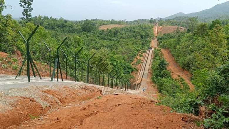
Scrapping of the FMR can be done in a short time but border fencing will take a fairly long time. Even the 10 km stretch near Moreh which was sanctioned still could not be completed due to various reasons and only 6 km have reportedly been completed.
FMR is a unique system where inhabitants of the border areas are allowed to cross the boundary without a passport or visa; this is not available elsewhere. Traditionally Asians were not too much bothered about their national boundaries unlike the Europeans and the boundary fluctuates depending on the might of the ruler. After the colonisation of the Asian countries by the European, the concept of national boundary was introduced.
During the period of colonisation of the two countries by the British with Burma coming under British India in 1886 after the Third Anglo-Burmese War there was no restriction of citizens crossing the borders as they belong to the same country. This followed even after British Burma was separated from British India in 1937. Most of the border, except for the portion falling under Manipur, was never under a proper empire and the boundary was all drawn on paper; separating communities by the artificial drawn line.
Most of the areas are classified as Un-Administered Areas. It was told that when MK PB and his friend Yarrow from 2 Assam Regt after WWII decided to tour the Naga Hills, they even visited Bhamo, now in Kachin State, Myanmar where the headman proudly told that Meitei paddy was grown. The only instructions given by the Civil Officers is to avoid certain villages where the inhabitants are hostiles to visitors.
The boundary between Manipur and Burma was fairly clear though there are conflicts now and then. By the 17th century, the eastern border of Manipur stretched up to Ningthi River (Chindwin) but after the conquest of Manipur by Awa leading to the Chahi Taret Khuntakpa (1819-1826) and with the signing of the Treaty of Yandaboo in 1826 and the subsequent Agreement of Sunnyachil Ghat in 1834, Kabo valley was handed over to Burma.
In 1833, Pemberton the Political Agent started demarcating the boundary between the two countries and with no conflict on the north; Boundary Pillar 1 was erected near Kongkan Thana and continued up to Manipur River. In 1881, Johnstone again redid the demarcation but unfortunately most of the BPs erected by Pemberton were untraceable. Again in 1896, Maxwell again redid the demarcation and the final line was called the Maxwell-Johnstone-Pemberton Line. However, even subsequent letters from the Political Agents in Manipur in the 20th century pointed out that Manipur was unfairly treated in the matter of the boundary.
After India, including Manipur, got independence in 1947 and Burma in 1948, there was no change in the regime for crossing the border. But things changed a little bit after 1950, when the FMR was introduced where under this regime, inhabitants residing within a distance of 40 km (25 miles) of either side of the border were allowed free movement with head load and necessary modification to the Passport Acts of the two countries was made. The intent was to continue with the long tradition where such inhabitants were free to cross the border, which was claimed as artificial.
A Burmese citizen can stay in India for 72 hours while an Indian can stay for 48 hours. Due to the Naga insurgency and the subsequent Meitei and Mizo insurgent movements with a view to check the free movement of the insurgents, changes were made in the FMR in 1968 with the introduction of a permit system. Permit was issued to those crossing the border with the government trying to keep track of those crossing the border but to no avail as the border is too porous.
In 2004, further changes was made in the FMR by limiting from 40 km to 16 km and crossing was permitted only through 3 identified crossing point-Pangsau in Arunachal, Moreh in Manipur and Zokhawthar in Mizoram but this also have limited impact as the border is porous and unfenced. The intent for the changes was not only to stop the free movement of insurgents but also to check illegal immigrants and stem the flow of illicit drugs and arms. In 2018, India and Myanmar signed a new Agreement on Land Border Crossing with an endeavour to facilitate regulation and harmonisation of the already existing FMR for people ordinarily residing in the border areas of both countries but to also facilitate movement of people on the basis of valid passports and visas to enhance economic and social interactions between the two governments.
The sudden announcement of scrapping the FMR and the erection of border fencing had focussed on the FMR and whatever changes in the FMR whether it continues or scrapped will have no impact on the movement of border inhabitants and even now despite the crossing point is Moreh, in Manipur people cross the border wherever they like. So, the only way to fulfil the objective is to erect border fencing which as mentioned, two border states have expressed their objections.
Even in the Manipur portion of the 398 km stretch, it will not be easy to erect the fence. After merger to the then Dominion of India, the responsibility of the borders vest with the latter and the two governments of India and Burma entered into a bi-lateral Treaty on 10th March, 1967 at Rangoon. The formal boundary delimitation and demarcation was carried out on maps and an Instrument of Ratification was signed on 30th May, 1967 at New Delhi. The tragedy is that none from Manipur was aware of the proceedings; the biggest stakeholder on the Indian side is kept in the dark.
During the physical demarcation the state of Manipur or the local people was hardly represented. Thus in many places the boundary as envisaged by the locals was different from the new alignment. Further, as the erection cannot be done on the boundary line and need to be erected some 50-100 feet towards the Indian side, the locals oppose tooth and nail as they are surrendering large tracts of land. Further, due to the terrain a uniform distance from the border cannot be maintained leading to allegation of favouritism. Even in the erection of the 10 km stretch, there were serious conflicts, delaying the work. Thus the announcement and realisation will be totally different and it may take decades.
Many mainlanders expressed that illegal immigration of a few lakhs during the last three/four decades is not much and why is the people of Manipur so concerned. For those coming from big states like UP, Bihar, WB, etc a few lakhs may be irrelevant but for Manipur it totally changes the demographic profile of the state; it is worse at the district level. So much so that areas like Kangpokpi, Tengnoupal and Chandel are now totally dominated by the Kuki-Chin while earlier these were dominated by the Naga. Moreh which was inhabited by a few Kuki from the Baite and Mate tribes and was much less than the Naga population till 1992 is now dominated by the Kuki which now form more than 50% of the population of the town. If say, a few crore migrated to these big states, they will also strenuously object. It is not only the absolute number but also the relative number that counts.
The people living along the borders will no doubt feel concerned by the announcement of UHM. But there is no FMR with Bangladesh, though communities on either side are similar with religion being the major difference. India has to take into consideration its internal as well as external security angle. The two measures are towards this end and despite objections from two states; it will go through the process.
However, it would be more prudent to erect the fence on priority and patrol it regularly by dedicated border patrols specifically trained. Assam Rifles are not trained for border duty and the proposal to utilise 26 Bns of AR for border duty will need the officers and men retrained for the purpose. BSF, ITBP, etc which are dedicated border guards will be more suitable as both the officers and men specialised in this duty. AR should be allowed to concentrate on CI ops. Without patrolling and relying on ambushes is no way to guard borders. To assuage the concern of local inhabitants, FMR may be continued but the crossing must be strictly through the identified crossing which may be increased a bit in number, with the focus on border fencing.
(The views expressed are personal)