

Unplanned urbanisation in a highly seismic sensitive zone state such as Manipur in Northeast India region may lead to massive destruction and heavy loss of lives and properties in the event of high intensity earthquakes, experts in the state caution.
Imphal, the capital of Manipur, is located above massive deposits of alluvium of fluvio-lacustrine origin within the Indo-Burma subduction zone, which is considered to have one of the highest seismicity levels, according to the Bureau of India Standards, 2002.
Atom Sunil, assistant professor of Pravabati College, said North-eastern India, particularly Manipur, has become one of India’s most earthquake-prone regions.
Anthropogenic activities such as construction of tunnels, highways, dams, mining and other infrastructures are also found in the region’s rugged terrain.
Many constructions are erected on the flanks of hills and valleys. The buildings are of inferior quality and lack scientific underpinnings. It increases the possibility of earthquake-prone locations.
Sunil said many factors, including geological structure, soil types, low-living conditions, relief features and anthropogenic activities among others contribute to high vulnerability to earthquakes in Manipur.
According to Sarda Maibam, assistant professor of Manipur University, department of Earth Science, all engineering construction must rest on or below the earth’s surface, hence it is important to understand the geotechnical properties of various soil types.
In order to determine whether the foundation site is secure and durable enough to support an engineering structure, geotechnical investigation is an essential part in the construction process.
Manipur, particularly in the valley area, is one of the developing places in India where lots of engineering structures have been constructed in the last decades.
As the population of Imphal city in the valley area is significantly increasing resulting in expansion of urbanisation, the vulnerability to natural disasters such as earthquakes will also increase, Sarda Maibam explained.
The region consisting of both plain and hilly terrain has been witnessing a lot of tectonic stress and an increasing number of earthquakes over the years. Considering it, experts fear that events of magnitude 8.0 or more on the Richter scale may be around the corner.
Some of the major earthquakes recorded in Manipur since 1926 are: March 15, 1927 - at East of Thaung, Sagaing Division (Indo-Myanmar Border region); June 2, 1934 - magnitude 6.5 on Richter scale at East of Ukhrul, Manipur (Indo-Myanmar Border region); May 6, 1938 - magnitude 6.5 on Richter scale at East of Ukhrul, Manipur (Indo-Myanmar Border region); May 27, 1939 - magnitude 6.7 on Richter scale at South of Palel, Manipur; July 1, 1957 - magnitude 7.2 near Moirang, Southern Manipur;
August 6, 1988 – magnitude 7.2 on Richter scale in east of Imphal (Indo-Myanmar Border region), 00:36:24.6 UTC, 25.149N, 95.127E, 91 km depth. Three people were killed in this earthquake. Tremors were felt over much of eastern and north-eastern India, Bangladesh, Bhutan, Eastern Nepal and Myanmar. It was also felt as far as Kolkata and Patna. Some damage was also reported from Homalin in northern Myanmar on August 6, 1988; On January 4, 2016, Richter scale magnitude 6.7 earthquake had its epicenter in Manipur's Tamenglong district. Bangladesh, Myanmar and Bhutan felt the quake too. At least nine persons were killed and over 100 injured.
Hence, there is every possibility that Manipur may experience more such tremors in the future.
Despite the great advancement in science and technology, mankind is yet to come up with a mechanism that can predict an earthquake in advance.
How earthquake resistant are the structures that have come up haphazardly all over the place, particularly in commercial areas of Imphal?
How well prepared are the people to face the situation when an earthquake strikes?
Have any steps been taken up to sensitise the young children on what to do in the event of an earthquake?
Also, it is important to question whether any arm of the government has been trained on how to respond to the situation in the face of an earthquake.
The Centre for Research and Advocacy, Manipur (CRAM) has expressed deep concern that several mega structures, especially Singda dam close to the epicentre of the tremor, has also developed cracks. Further, there are reports about caving in of some tunnels of Trans Asian Railway in Tamenglong and the towers of World Bank funded High Voltage Transmission lines.
The inability for these mega development structures to withstand the seismic activity on 2016 at 6.8 Richter scale indicates the seismic aspects and impacts, especially in Manipur which is juxtaposed in high and active seismic zone, within the folds of Himalayan Mountain range has either not been considered or disregarded, CRAM said.
The epicentre of the January 4 tremor in Tamenglong district should be viewed for due consideration and sensitivity to the repeated assertions from academicians, technicians and civil society organisations that Manipur’s proximity and location in a “very high seismic zone 5” requires a cautious and inevitable consideration of seismic aspect and impacts in all development planning and processes, it stated.
The proposed plans for building the Tipaimukh Dam, Pabram and Irang Hydel projects and other mega dams under the Manipur Hydro Power Policy, 2012, the proposed Oil Exploration Plans in Tamenglong and Churachandpur districts, the extensive tunnelling and construction works for both Trans Asian Railway and Trans Asian Highway and multitude of other large-scale development projects within Manipur need serious introspection for their feasibility and rationality in places like Manipur, it pointed out.
There should be a clear review of the existing mega development structures like Mapithel dam, the Singda dam, Khuga, etc for their compliance or due consideration of seismic impacts.
This natural calamity should also lead to a development decision based on rightful participation of all indigenous communities and those concerned with a just and a sustainable development in Manipur, said CRAM.
A table top exercise for state-level mock exercise on earthquake scenarios was conducted in April 2022 to check the preparedness for an earthquake disaster at state level and to give awareness to the people. While earthquakes cannot be predicted, their impact can be mitigated through advanced planning and adequate disaster management preparedness.
It is a welcome step that Northeast states are contemplating measures such as adoption of a common building code different from the rest of India.
According to the Public Works Department, the government of Manipur 2017 report quoted the state as “very high risk” of earthquakes. According to the Global Seismic Hazard Assessment Program (GSHAP) data, Manipur falls in a region of high to very high seismic hazard. As per the 2002 Bureau of Indian Standards (BIS) map, Manipur also falls in Zone V. Earthquakes of low to moderate intensity are recorded in the state regularly.
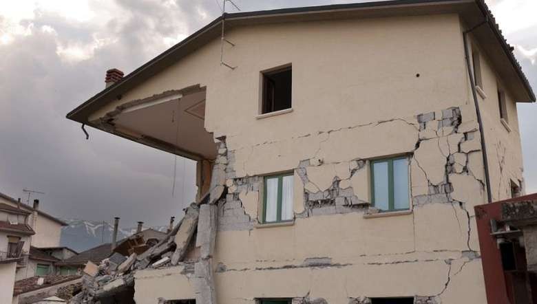
The state of Manipur has weathered dozens of large earthquakes, the biggest in recent times being the 1988 M 7.2 earthquake. Limited awareness, lack of preparedness, structural weaknesses of the buildings, flouting of bye laws by public and high population density make the state highly vulnerable to daytime earthquakes.
Whole landmass of Manipur is in seismic Zone V. An Earthquake of magnitude 8 or above will lead to a large number of injuries, loss of life and heavy damage to infrastructures. In such a scenario, human life is in high danger. If no action is taken right now, the problem will worsen due to the population growth, increased construction of unplanned buildings and poor knowledge of private construction agencies regarding EQ resistant design and geotechnical considerations in making risk resistant construction, according to the PWD report.
According to GSHAP, Manipur is situated in the most earthquake prone zone in the country (Seismic Zones -India 2001). It keeps on experiencing minor tremors on and off. Seismologists, on the basis of past patterns have predicted that a major earthquake is almost overdue in the Northeast India region (Tiwari 2002).
The report also stated that the soil cover of Manipur can be broadly classified into two types namely; red ferruginous soil which is seen in the hilly area and alluvium soil in the valley area. The soil of valley regions commonly contains small fragments of rocks, loam, sandy clay and sand and they are quite diverse.
The steep slopes consist of a very thin top soil and these top soils of steep slopes are subjected to high soil erosion which results in culverts and infertile rocky slopes. Owing to its geo-climatic, geological and physical features, Manipur is vulnerable to all major natural hazards (drought, flood, earthquake, landslides, fires etc.).
Most earthquakes in western Manipur are shallow. But some, especially those recorded in the eastern parts and along and across the Myanmar border have greater depths. Areas in central Manipur are especially vulnerable to damage during earthquakes as they lie in the Imphal valley, the lowest point of which lies the Loktak Lake. Much of the valley floor provides for strong shaking from even far off quakes as its soft soil amplifies the wave motions.
According to the PWD, in Manipur, while all the districts are vulnerable to earthquakes, the damage is most likely to occur in Imphal town, which has multi-storey buildings built without any consideration for earthquake resistant construction.
For earthquake mitigation, experts suggest discussion of earthquake safety at home and in the office, revision and adoption of model building bye-laws for construction, both in urban and rural areas in association with transmission control protocol (TCP) and municipal bodies. They also suggest practices such as wide dissemination of earthquake-resistant building codes, the National Building Code 2005, and other safety codes and construction practices. They suggest launching demonstration projects to disseminate earthquake-resistant techniques. Launch awareness campaigns on seismic safety and risk reduction and sensitizing all stakeholders on earthquake mitigation are needed.